It was overcast and windy, there was that typical late September end-of-season atmosphere in Bude. I walked past the unusual outdoor seawater swimming pool. It was closed at the time because the tide was in, big waves washing over the top. I saw rows of tired beach huts that looked like they could do with a lick of paint. The walking was easy as I left town. Once again signs of erosion and crumbling cliffs were frequent. At Northcott Mouth there was nobody else around. I could see distinctive anti-tank war defences where the stream flows onto the beach. They must have been very well built to survive this long without being destroyed by stormy seas. The climb there was the first of note today, though nothing too bad. I considered it a warm-up for what was to follow later.
At Sandy Mouth the path stays above the beach so I didn't see much. A couple with a baby strapped to the father were just setting off from the almost empty car park to walk towards Bude. The going stayed fairly easy as I moved on to the pleasant valley at Duckpool. This was a nice spot with a classic oxbow river that was being enjoyed by a few local dog walkers. There was a strong wind and the sea was high, I didn't expect I'd see anybody in the water today.
The steepest climb yet took me up to Steeple Point. Now the Morewenstow GCHQ listening station was right in front of me. I found the place fascinating. It's only when you get close you realise just how big it is. There are several huge dishes pointing at different parts of the sky, mysterious domes. Security looked to be much tighter than at any other government installation I'd seen on this coast walk so far. Signs fixed to the outer fence warn that photography isn't allowed. I couldn't resist taking a couple of quick pictures from a bit of a distance, hopefully they're not a threat to national security. I have no idea whether or not I was being watched on the CCTV cameras, but nobody came to arrest me!
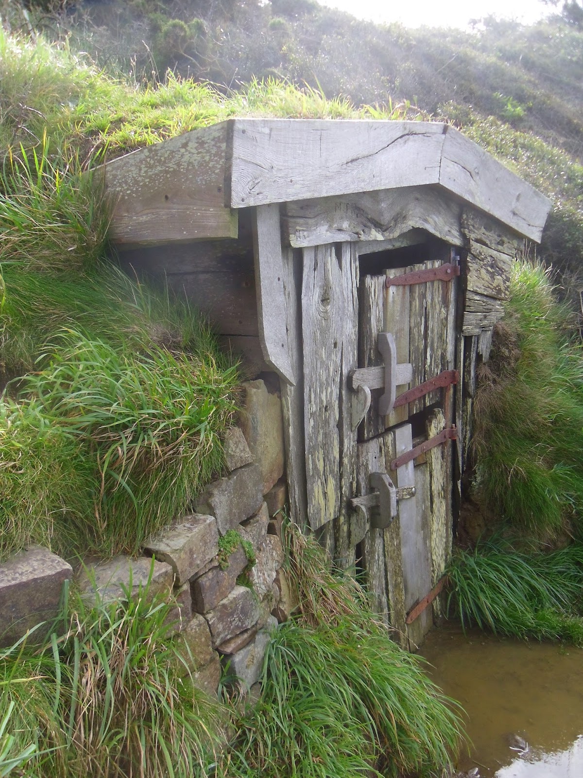
Crossing the stream at Stanbury Mouth I saw other long-distance walkers for the first time today, a family, two teenagers and their parents heading south, Scandinavian I think. The going was starting to get noticeably hilly now. The descents were awkward, muddy and slippery underfoot after over-night showers, the climbs getting longer and steeper. After another tricky descent and steep climb at a valley called Tidna Shute I saw a sign that shows where a short path leads down to Hawker's Hut at Vicarage Cliff. This fascinating structure, made from driftwood by eccentric clergyman and poet Robert Hawker in the nineteenth century, is the smallest property owned by the National Trust. I opened the door and sat inside. For a few minutes I enjoyed the magnifient views and looked at the graffiti etched on the interior over the decades. Looking back up at Vicarage cliff later I found it impossible to spot the well-hidden hut.
Cornwall had a sting it's tail. After Tidna Shute there were another two similar deep gorse-filled valleys to negotiate, each with a small footbridge at the bottom. Then I reached the Devon border at Marsland Mouth. I stopped on the footbridge, one foot in each county, with mixed emotions. Entering North Devon was a pleasing landmark, I was very happy to make it back to my home county. However I was also sad to leave Cornwall. The twelve days I'd spent walking around the county's spectacular 300 mile coastline since my arrival on the Cremyll Ferry a year ago had been absolutely unforgettable. The Cornwall coast is so beautiful I would have been quite happy if it just carried on forever.
Marsland Mouth itself was a lovely place to re-enter Devon, much easier on the eye than the last three valleys I'd walked through in Cornwall. The stream here has carved-out a delightful small gorge. There was a large house in a wonderful position at the head of the valley, horses grazing in the fields, it looked great in the sunshine which was now starting to burn away the morning clouds.
Devon also let me know in no uncertain terms that the terrain wasn't going to be getting any easier just yet. Leaving Marsland Mouth required another a long steep climb. Near the top I came to wonderful Ronald Duncan's Hut. It is well kept and clean, contains a table, two chairs, two large bottles of fresh drinking water with glasses, and a guestbook. There are displays full of information about the late author who wrote his poetry and plays here. Ronald's hut is always open to passing walkers, maintaining this place of rest and shelter in such a remote location is a wonderful gift from his family to passers-by. I spent several minutes in the hut and signed the guestbook before moving on.
On the hill above Ronald Duncan's hut and Marsland Mouth I was pleasantly surprised to find a memorial bench dedicated to a man called Harold Keays. It gave a fantastic view over Welcombe Mouth and was the perfect place to stop for lunch. After a short rest I walked down into the valley. Welcombe Mouth itself was lovely. There was a series of pretty waterfalls, the stream then running into the sea between spectacular lines of jagged rocks. Leaving required another very steep climb from sea-level to around 350ft, probably the toughest of the day. There were no steps, the only way to get to the top was by scrambling as best you could up a loose stony surface that was crumbling and uneven.
Once at the top the going suddenly got easy again. I passed the ramparts of the Iron Age hill fort at Embury Beacon. Then there was a short section on a country lane that looked and smelled like it only gets used by tractors and muck-spreaders. Lundy was getting closer than ever. It looked much taller than when I'd first noticed the island back at Godrevy Head. I realised that back then I must have only been able to see the very top of the island, most of its height still being below the horizon. Now I was close enough to make out buildings and other features.
At Mansley Cliff I could see Hartland Quay ahead. It looked quite close, but it would still take a while to get there yet. For some reason the official coast path goes around the back of Swansford Hill rather than over the top, a rare case of sacrificing views to take an easier route. Just after there I saw people for the first time since Welcombe Mouth, two excited women with cameras looking over a cliff. I soon realised why, there were lovely waterfalls there, the best of the day, one of them quite tall and flowing well.
After distinctive St.Catherines Tor, which looks a bit like Glastonbury Tor sliced in half, there was another pretty waterfall. I overheard people there happily agreeing it had been worth making the difficult walk from Harland Quay to see! After a rugged but relatively easy stretch of path over the final headland of the day I made my way down into the lower car park Hartland Quay where Lea was waiting. After a day of fairly short mileage by my standards it felt a bit odd finishing mid-afternoon.
So, is Bude To Hartland Quay toughest section of the South West Coast Path?
That depends who you ask.
After walking it myself my answer is 'No, it definitely wasn't for me. But I can see why it is for many other coast walkers'.
Between Morewenstow and Marsland Mouth the terrain was very demanding. There is a series of steep, deep valleys which even the fittest among us would find a struggle. In that area I agree, the coast path is as difficult as it gets. However there are also several miles of relatively easy walking either side. Personally I thought my days 23 and 24 were both harder than today. When I looked-up the numbers this feeling was confirmed by the ascent data recorded on my GPS device;
4,545 feet of ascent on day 23.
5,680 feet of ascent on day 24.
4,194 feet of ascent on day 25 (Bude to Hartland Quay).
It comes down to how many miles you prefer to walk per day. Most coast walkers would break-up my days 23 and 24 into two shorter sections each. Those who do would rightly consider the walk I made today to be more difficult than any one of those four. To me the walk from Bude to Hartland Quay didn't seem particularly difficult because it was about a third shorter than my usual daily average. In planning I'd considered going on to Clovelly today. If asked I'm confident my legs could have managed it without too much difficulty.
The walking had to go on pause at Hartland Quay. Unfortunately that's all I have time for in 2015. We'd enjoyed a fantastic holiday on the coast. I feel incredibly lucky to have walked through so many beautiful places over the last six days. The brilliant South West Coast Path never ever disappoints.
I'd like to say a massive thank-you to Lea for doing a fantastic job supporting me in the car all week. As we drove home to Exmouth plans were already underway for our return in April 2016 when I intend to complete the remaining 108 miles to Minehead.
Thanks for reading, Gary.
Distance Walked Today 15.57 miles (25.06km)
Walking Time; 6 hours 16 minutes
Average Walking Speed 2.5 mph
Cumulative Distance Walked 556.77 miles (896.03km)
GPS Track; http://rnkpr.com/aaw2ynq
 |
| The salt water swimming pool being overwhelmed by waves at Bude |
 |
| Easy cliff-top walking to start the day |
 |
| The GCHQ listening station at Morwenstow |
 |
| Hawker's Hut |
 |
| View of the first hill in Devon, picture taken in Cornwall. Marsland Mouth is in the foreground, Ronald Duncan's Hut is near the top of the hill |
 |
| The South West Coast Path crosses from Cornwall into Devon on this footbridge at Marsland Mouth |
 |
| Ronald Duncan's Hut |
 |
| Waterfalls at Welcombe Mouth |
 |
| Jagged rocks on the beach at Welcombe Mouth |
 |
| View from Mansley Cliff, Lundy is on the horizon, St.Catherine's Tor just right of centre, the white rooftops are at Hartland Quay |
 |
| Waterfall just north of St. Catherine's Tor |
No comments:
Post a Comment